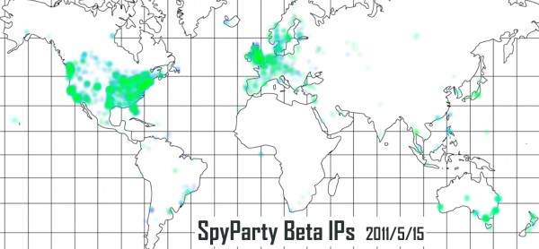
Location, Location, Location
It is true: I should be working on the game right now. But I couldn’t resist more beta data! Here are 5,871 geolocated SpyParty Early-Access Beta IP addresses:
A few things of interest:
- I started to color code the points by the time they registered, and then I thought I’d do a gif animation over the duration of the beta, and then I realized I’d already spent way too much time on this!
- I got a flurry of Japanese sign ups and tweets, mostly referencing this nice article on 4Gamer.net. I should probably have the sign up page translated into Japanese and Korean…
- Are there really a bunch of sign ups from Arviat, NU, Canada, or is that a bug in the free IP geolocation database I used, or my code? Also, Sao Tome? Oh, wait, duh…Sao Tome is right near 0,0 lat/lon, so that’s probably just a bug! Arviat is a mystery, though.
- I got the map image from here, but be warned, one of their “Mercator” projections isn’t. I thought I had a math bug for an hour or so in the code I hacked up to render this.
Okay, back to work on the auto-updating and content packing! Fun fun fun!


Hmmm… well, in a couple months I’ll be moving to the Rocky Mountain area from my current location in the Pacific Northwest of the USA. You should probably make another map at that point in time! :P
The “international awareness” of SpyParty is pretty awesome!
I’m in the Iceland blob, and hope I get to do beta
You definitely will (everybody who signs up will, I need to update the FAQ), and thanks for signing up!
Well, it could be worse!
Had you gone by facebook location data, you’d be getting a hit from Elephant Island!
All the stone heads on Elephant Island get into the beta for free. Edit: Oh, wait, not Easter Island, oops! :) I wonder what the ping times from Elephant Island are…
Easter Island*
Hah!
Only thing Elephant Island is good for is Shackleton’s journey there after they got stranded on antartica!
Ooh ooh ooh! I think I see my house!
I’m from the gigantic mid-to-East US blob.
http://www.online-station.net/news/game/22105 << News From Thailand
Awesome, thanks for the link!
Is it me, or does it seem like it just skips over Oregon completely? lol, WE ARE HERE AND WE WANT TO ENJOY IT CHRIS!
Nice. Congratulations for all the interest you have generated. I’m really excited to try the game.
By the way, what software/code did you use to colour the map?
Absolutely fabulous! I’m in the northern scandinavia blob ;)
What did you use to render the map, if you’d care to give a short comment?
A bunch of totally hacked terrible code I wrote, filled with stuff like this:
    assert((w == 1236) && (h == 1165));
    MercatorAspectRatio = float(w)/float(h);
    EquatorY = float(h-565)/float(h);
    MeridianX = float(618)/float(w);
    LatScale = (float(h-456)/float(h) - EquatorY)/0.549306144335f;   // 30 degrees
    LonScale = 1-MeridianX;
or this:
vector_2 XYFromLatLon( float lat, float lon )
{
    float x = MeridianX + LonScale*(lon/180.0);
    lat = RadiansFrom(lat);
    float y = EquatorY + LatScale*log((sin(lat) + 1)/cos(lat));
    // return vector_2(WindowWidth*x,(WindowWidth/MercatorAspectRatio)*y);
    return vector_2(MercatorAspectRatio*x,y);
}
and this:
    glBindTexture(GL_TEXTURE_2D,BlobTexId);
    glEnable(GL_BLEND);
    glBlendFunc(GL_SRC_ALPHA, GL_ONE_MINUS_SRC_ALPHA);
    glBegin(GL_QUADS);
    for(uint i = 0, ni = IPAddresses.size(); i < ni; ++i) {
        uint ip = IPAddresses[i];
        geo_ip_range* range = FindIPRange(ip);
        if(!range) {
            continue;
        }
        geo_location* loc = FindLocation(range->locid);  assert(loc);
        float r = 0.007f, a = 0.15;
        vector_3 green = RGBtoHSV(vector_3(0.0f,1.0f,0.0f));
        vector_3 blue = RGBtoHSV(vector_3(0.0f,0.0f,1.0f));
        float t = float(i)/float(ni);
        vector_3 c = HSVtoRGB(t*green + (1-t)*blue);
        glColor4f(c.x,c.y,c.z,a);

        vector_2 xy = XYFromLatLon(loc->lat,loc->lon) + r*vector_2(genrand_real_cc()-0.5f,genrand_real_cc()-0.5f);
        float z = i*1e-7f;
        glTexCoord2f(0,0); glVertex3fv(make_v3(xy-vector_2(-r,-r),z).el);
        glTexCoord2f(1,0); glVertex3fv(make_v3(xy-vector_2( r,-r),z).el);
        glTexCoord2f(1,1); glVertex3fv(make_v3(xy-vector_2( r, r),z).el);
        glTexCoord2f(0,1); glVertex3fv(make_v3(xy-vector_2(-r, r),z).el);
    }
    glEnd();
Etc. Basically, I downloaded the geolocation csv files and map I mention above, figured out where the important parts of the map were in the image, load it in, render it as a texture, then look up all the IPs and splat them down as a little gaussian alpha blob texture.
Ah, I get the gist, thanks :)
Whoa, totally cool.
Gosh, my whole state is covered in blue/green.
I’m the Guam blob.
I wonder who those people are in the middle of no where.
That’s my 100 signups. :P
That’s actually a really good question. I wonder…
They could be using Tor or another proxy server or something too.